Google Analytics

Showing posts with label walking. Show all posts

Saturday 27 July 2024

Compass

My first compass, from 1973. And I still have its 24-page instruction leaflet. 

The leaflet goes into great detail, enough to enter an orienteering competition, but I used the compass mainly to check I was heading roughly in the right direction. When you are walking the twenty-five miles through the mountains from Rannoch to Fort William in the Scottish Highlands, the last thing you want is to go wrong at the high watershed and somehow find yourself miles astray at Kinlochleven. I suppose most would use a SatNav now. 

Another brilliant walk was around the hidden, Blea Gill Waterfall near Grassington in Yorkshire. You follow the track along the Western side of Grimwith Reservoir (since considerably enlarged) to Blea Beck, and then climb to the top of the waterfall to Grassington Moor. A circular anti-clockwise route takes you back via Hebden Beck to the starting point on the B6265 road. 

Route around Blea Gill Waterfall (1967 1-inch map)

It was wild above the waterfall, very boggy, with few obvious tracks. There were centuries-old, disused lead mine workings, chimneys, shafts, and spoil heaps, a strangely beautiful landscape of industrial desolation, deserted by the legions of miners that once toiled there. You saw no one else all day, and without a compass it would have been easy to lose your bearings. Proper walking. I am told it has now been cleaned up with signposts, notice boards, and warnings not to fall down the concealed mine shafts. 

Blea Gill Waterfall, Grassington Moor,1974
Blea Gill Waterfall, 1974
Grassington Moor now

I then looked for routes needing more precise compass work. I remember walking with friend Neville up to Alport Moor from Howden Reservoir in the Derbyshire Dark Peak. The ascent passes through dense evergreens before reaching open moorland, which levels out gradually, curving up so you cannot see the top until almost there. Neville looked dubious when I said the Alport Moor trig point was a little way straight ahead, and indeed there it was. He had complete faith in my map reading after that, often misplaced. 

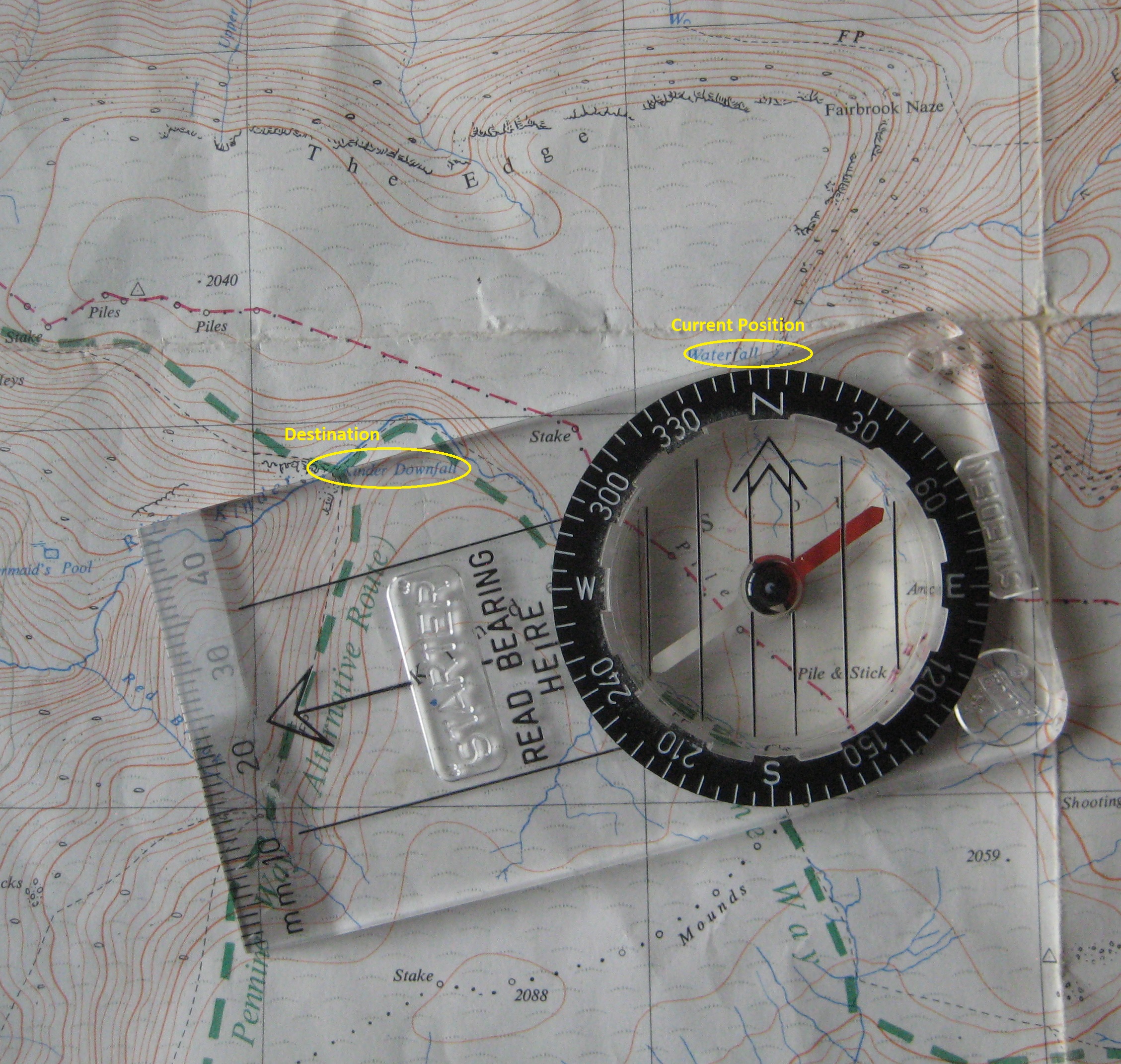
We also liked to cross the Derbyshire moorland plateau of Kinder Scout, from Fair Brook to Kinder Downfall. I wrote about it here. It is not far across, but the maze of deep, watery, peat ridges and trenches known as hags and groughs, twisting and turning in all directions, make it impossible to keep to a straight line. All distant features are below the horizon, so there is nothing you might aim towards. Unless you check your compass every few yards you go hopelessly off-course. 

Navigating With The Compass

From the top of Fair Brook to Kinder Downfall you follow a bearing of about 255 degrees, but you do not really need to know about bearings. All you have to do is set the compass using the map, and then follow it. Well, that is how I do it. 

The needle of the compass points red to the North. It swivels inside a black dial, which can be manually rotated on a transparent base plate. The base plate has a large arrow pointing away from the needle. 

You place the compass on the map with the large arrow pointing roughly in the direction you want to go, and then slide it so that one of the long edges of the base plate passes through both your current position and your target destination, e.g. from the top of Fair Brook to Kinder Downfall as circled in yellow in the photograph. You then rotate the dial so that North on the dial matches the grid lines on the map. There are lines inside the dial to help with this. It does not matter which way the map or the magnetic needle are pointing at this stage. 

Setting the compass: Fair Brook to Kinder Downfall

You can then put the map away for a while. Stand up and hold the base plate level with the large arrow pointing ahead of you. Slowly turn round until the red needle lines up with North on the dial, and walk straight ahead. It helps to choose a distant feature to aim towards, if one can be seen. 

There is a lot more to it, but I usually find this sufficient. You could adjust for the difference between Magnetic North and Grid North, but over short distances it probably does not matter much, so I am not going into that. It makes only about 2 degrees difference at present, although in past decades it has been as much as 10. It slowly changes. It is also worth mentioning that map grids do not always point to True North, but, again, it does not really matter. I could explain these different kinds of North, but do you really want to know? 

The 24-page leaflet explains all this in greater detail. I have archived a PDF copy here, in case you are nerdy enough to be interested. 

As mentioned at the start, this was my first compass. I later bought a new, supposedly more accurate mirror compass, but never got the hang of it. I simply fold out the mirror and use it in the same way as the old one. I believe that for greater accuracy you can read the needle through the mirror, and look at objects through the hole and the notch. I am told that you can even measure heights, if so inclined. But I would rather enjoy the countryside than study for qualifications in surveying. At least the new compass fits neatly into your trouser pocket without any sharp corners to castrate you when you sit down. And the mirror allows you to check your face is still perfect after a long day out in the wind and rain. 

Monday 1 July 2024

Road To The Isles

New Month Old Post: first posted 2nd June, 2016
Sure by Tummel and Loch Rannoch and Lochaber I will go
As step I wi’ my cromack to the Isles.
Rannoch Moor fires the imagination with mystery and romance: the myths and legends; the forgotten history; the departed people; the abandoned ruins; the strange Gaelic names.

Said to be one of the last remaining wildernesses in Europe, it is a bleak stretch of blanket bog, lochans and rocky outcrops to the West of Loch Rannoch in Scotland. The West Highland Railway crosses it on the way to Fort William and Mallaig, over peaty terrain so wet that the Victorian engineers had to float the track on a mattress of brushwood, earth and ashes to stop it sinking into the bog.

Rannoch Viaduct 1975

Other than by train, the only way to Rannoch Station is by thirty miles of narrow B road meandering along the northern shore of Loch Rannoch from Pitlochry or Aberfeldy. Neville, Kev, and I, had driven there the previous Easter to sit cheerfully swigging our pints outside the Moor of Rannoch Hotel in the warm April sunshine. We watched a goods train rumble slowly north across the Rannoch Viaduct.

But it was the enigmatic wording of the signpost that caught our attention:

Road to the Isles signpost at Rannoch

PUBLIC FOOTPATH TO
FORT WILLIAM BY CORROUR
(THE ROAD TO THE ISLES)

What a walk that must be!

The following year, Easter was a full two weeks earlier and the seasons over two weeks later. A letter from Major J. D. Rennie of the Moor of Rannoch Hotel, Rannoch Station, Perthshire, replying to our enquiry, said that, yes, we could leave our car at the hotel for a few days provided we left the keys so they could move it if necessary. However, he still seemed surprised when we turned up in the snow. We camped that night beside the nearby lochan. By morning, the pan of water left outside had frozen solid. At least it was too cold and early in the year for the midges.

It would not be beyond endurance to walk the thirty miles from Rannoch to Fort William in a day, but it seemed ideal for a first attempt at backpacking. We loaded our aluminium framed rucksacks, left the car keys with the Major, and set off northwards beside the railway track. And apart from the railway track, there was little else to see for the first ten miles but vast, uninhabited empty moorland. Being Easter Sunday, there weren’t even any passing trains to disturb the isolation. Remote, beautiful, desolate! We saw no one else all day.

The land gradually rises to a summit beyond Corrour, the next station on the line. It was shrouded in mist. The station, since made popular by the film Trainspotting, is now busy with walkers and mountain bikers, and Corrour Station House is a popular restaurant and guest house, but in 1975 there was very little there. We passed without much pause heading for our first overnight camp at Loch Treig. It could not come soon enough. My feet were a mess. Idiotic to attempt such a walk in new boots.


The next morning, bright sunshine reflecting from the loch and mountains bathed everything in a brilliant blue light. We set off west, away from the railway, along the southern shore of Loch Treig. The loch is dammed at the northern end, and two lost communities, Kinlochtreig and Creaguaineach, lie submerged beneath the waters close to where we were. As if drawn to them, my blistered feet refused to go far that day and we camped again about a mile and a half beyond the loch, near the Staoineag ruin beside the Abhainn Rath river we were following. There was wood to light a fire and, again, no one around to complain.

 Loch Treig

We covered about eight miles on day three, struggling with our heavy rucksacks across difficult ground. Continuing west, the river becomes angrier and whiter, the wide banks giving way to a steep-sided valley sparsely lined with silver birch. It then becomes still again, with banks of stony mudflats, and the country opens up into wide, browny heath and moorland. But as you approach the once fine house of Luibeilt, now a lonely ruin, you have to ford the river.

Near Luibeilt

We knew the technique. Trouser legs up, socks off, boots back on, wade across with caution, and most importantly, do not lose your footing. The river was not particularly high and should have been trouble free, but it wasn’t. At least I was not the one to slip and fall in, losing the capacity either to give or refuse consent to be photographed ignominiously paddling out.

While drying out, two countryside rangers waded across, the only others we saw on the whole walk. As you would expect, they made it look easy. We chatted with them for the next few miles. They asked whether we had been staying at Luibeilt. It was listed by something called The Mountain Bothies Association as a place of overnight refuge. It sounded good for the future and I joined fairly soon afterwards. 

The rangers sped ahead and disappeared into the distance as we approached the east-west watershed where the water flowing east towards Loch Treig along the Abhainn Rath becomes the water flowing west to Fort William down the Water of Nevis. Several valleys converge here and it was not immediately obvious which one to take, but a bit of map and compass work put us safely in the right direction. No G.P.S. in those days. The slight uncertainty makes for much more fun.

Mountains above Glen Nevis

We camped again surrounded by the mountains of the Nevis valley: Aonach Beag, An Garbhanach, and Binnein Beag where deer came down the slopes in the night and made their way back up the next morning, avoiding the worst of the snow that sprinkled the tent.

Higher Glen Nevis

We were soon up and on our way again, descending through the steep gorge of Glen Nevis to the end of the road at the base of Ben Nevis, where the misspelt signpost indicated whence we came.*

Public footpath
to Carrour 15
and Rannoch 25

Public footpath sign to Corrour and Rannoch below Ben Nevis

But that was not the end. We still had to face another five gruelling miles along the narrow road to the Glen Nevis camp site.

We allowed ourselves the next day off, and early the day after that packed up and hiked into Fort William for the train back to the car. It was a little further to walk than now. The original Fort William station alongside Loch Linnhe, with its turreted entrance on the main street, was still in use. It closed and moved east to the present site two months later.

Route: Rannoch to Fort William

Rail Ticket: Fort William to Corrour 1988
I did that walk twice again with different friends, once in 1978 and again in 1988, both times by taking the train to Corrour from the new station at Fort William, thus omitting the wearisome Rannoch to Corrour stretch. Sensibly, we also left one of our cars at the end of the Nevis road making it just a fifteen-mile walk – a good day out. On both occasions we were the only ones to leave the train at the deserted Corrour halt, to the incomprehension of the other passengers who looked down (both physically and metaphorically) from the carriage windows with bemusement at our cagoules, walking boots and daysacks. 

I doubt it would be such a solitary walk now that most days the train deposits scores of walkers and mountain bikers at Corrour to follow numerous routes around the moor. The station is used by over twelve thousand passengers per year, an average of over thirty a day, but probably many times more in summer and fewer in winter. “Like a Wallace Arnold bus trip,” my dad would have said. It is a privilege to be able to say I was there in quieter times, nearly fifty years ago, but it would be wonderful to go again.

Take it away, Andy:

https://youtu.be/KtsAfk6h8mI


Notes

* The same sign and post are still at Glen Nevis (or were until relatively recently). The sign is considerably weathered, but the spelling of Corrour has been corrected and further signs to Spean Bridge, Corrour Station and Kinlochleven affixed in both Scots Gaelic and English. 

On one of the later occasions there were signs of construction taking place at Luibeilt, but I see from more recent accounts that it is now a ruin without roof, woodwork or some walls.

I would not be so confident drinking water from mountain streams now. 

Saturday 1 June 2024

The Blue Mini

Morris Mini 1966
New Month Old Post: first posted 10th February, 2016

What do you think of those who, watching films or television programmes set in the past, say: “they would not have used the phrase ‘too right’ in the twenties”, or that nineteen-fifties midwives would never have taken such an attitude to abortion, or that a locomotive shown in a wartime scene had not been built until the fifties? Are they nit-picking pedants or defenders of authenticity? I am about to join them. 

In 2016, a television programme, “Back In Time For The Weekend”, took a family back to live as in the past. Episode by episode, their house and its contents were changed to how they would have been through the decades from the nineteen-fifties to the present day. Their furniture, decorations, kitchen and household appliances, and home entertainments were appropriate to the date. At the start of the series they had no television set or refrigerator, and they did not have a home computer until Episode 4 set in the nineteen-eighties. 

Episode 2 was about the nineteen-sixties, when car ownership became more common. Supposedly in 1961, the family were given a blue, D-registration Morris Mini (above). The problem was it was a 1966 Mini, in 1961, five years before it was first registered. I know because I had one, blue, D reg., exactly the same, as in my blog header. Was the BBC research department taking shortcuts? 

Those Minis had something called hydrolastic suspension. Instead of separate springs, the front and rear wheels were connected by pressurised pipes. The idea was that when a front wheel went over a bump, the pressure would tighten its paired back wheel to reduce the bounce. It was rubbish. Mine kept gradually losing pressure and sinking down into its wheel arches. It had to go every few months to be pumped up. It is astonishing after fifty years they found one that had not been scrapped years ago. The family of two adults and three teenage children in the programme would have weighed down the back and shone the headlights up into the air. 

Here is my uncropped picture taken on the Cam Gill Road North of Kettlewell late in 1974 as we were putting on our boots for a walk to the top of Great Whernside. It was blowing a gale on top, but we were able to shelter in the large hollow summit cairn. 

1966 Morris Mini near Kettlewell
Near Kettlewell, 1974
Great Whernside Summit Cairn, 1974

Tuesday 16 April 2024

Wainwright’s Mardale Green

Rosemary (Share My Garden) wrote about her visit to Tyneham, a village in Dorset abandoned in the Second World War because it was in an area needed for military training. The residents never returned.

She also remembered, as a child, picking gooseberries in the garden of a house in a village abandoned to the rising waters of a new reservoir.

Mardale Green

It reminded me of a passage in ‘Fellwalking With Wainwright’, which has haunted me since I bought the book in 1985. I think of it often. Oh to be able to write like Wainwright. 

I will never go to Mardale Head now without thinking of a summer’s day more than forty years ago when I walked over Gatescarth Pass and saw the valley of Mardale for the first time. It was a lovely vista. The floor of the dale was a fresh green strath shadowed by fine trees and deeply inurned between shaggy heights; beyond, receding in the distance, was Haweswater, then a natural lake. It was a peaceful scene, the seclusion of the valley being emphasised by its surround of rough mountains. Mardale was a bright jewel in the dark crown .... I remember that day so well. Many early memories have faded, but not that one. Down in the valley, I went along the lane to the Dun Bull between walls splashed with lichens and draped with ivy. There was no welcome for me at the inn, which for centuries had been a meeting place for farmers and shepherds and the scene of many festive gatherings. It was empty, unoccupied. Around the corner was the small church amongst fine yews: it was a ghostly shell, the interior having been dismantled and the bodies in the graveyard exhumed and reburied elsewhere. The nearby vicarage and a few cottages were deserted and abandoned. This was the hamlet of Mardale Green, delightfully situated in the lee of a wooded hill, but now under sentence of death. Birds trittered in the trees and my footsteps echoed as I walked along the lane but there was no other sound, no sign of life. Even the sheep had gone. There were wild roses in fragrant hedgerows, foxgloves and harebells and wood anemones and primroses in the fields and under the trees, all cheerfully enjoying the warmth and sunshine; but there would be no other summers for them: they were doomed ... Manchester Corporation had taken over the valley and built a great dam. The lake would be submerged beneath a new water level a hundred feet higher. Already the impounded waters were creeping up the valley. Soon the hamlet of Mardale Green would be drowned: the church, the inn, the cottages, and the flowers, would all disappear, sunk without trace, and its history and traditions be forgotten. The flood was coming and it would fill the valley. Nature’s plan for Mardale would be over-rules. Manchester had other plans, to transform Mardale into a great Haweswater Reservoir. And no doubt be very proud of their achievement ... I climbed out of the valley to Kidsty Pike. Looking back at Mardale Green from a distance, its buildings no longer seeming forlorn but cosily encompassed by trees and its silent pastures dappled by sunlight, I thought I had never seen a more beautiful picture. Nor a sadder one.


Wednesday 21 September 2022

Loch Muick

After the unrelenting succession of public duties and merciless scrutiny, no one should begrudge the King and Queen Consort a few days’ peace and quiet at Balmoral. That is where I would be in their place, with perhaps a couple of nights at Glas-allt-Shiel.

For me, events vividly brought back the time I lived near there. Place names from thirty-five years ago became familiar again, as did the way they rolled off the tongue. Best was “Pitterrr Cootterrr” (Peterculter)

One of my favourite walks then was the eight-mile circuit of Loch Muick (pronounced “Mick”) on the Balmoral estate. It was a comparatively undemanding way to experience the rugged Highland countryside, ideal for the short winter days or long summer evenings they have up there. I often took visiting friends there and must have done the walk more than half a dozen times. In those days you could park for free at Spittal, eight miles south of Ballater, and see no one else all day.

The walk is on public paths, so there are no access problems. One nutcase I worked with liked to plan his own off-path routes across the Balmoral estate and was more than once stopped by security.

Here is Loch Muick from the southern end (I didn’t take many photographs at that time, so all the images here are others’).

About half way around the walk in trees on the western shore of the loch (on the left in the photograph) is the lonely lodge of Glas-allt-Shiel, built by Queen Victoria in 1868 as an escape from the world after the death of her husband. The Royal Family still use it occasionally despite the lack of mains electricity.


Usually it was closed up, but on one occasion, although deserted, the blinds were open and you could see into a dining room exquisitely set with spectacular china and silverware. We stood at the window and stared in wonder for a time before continuing around the loch. Suddenly, three Royal green Range Rovers came speeding
along the track towards us. We couldn’t see who was in them.

My only other brush with Royalty was when the Queen visited the university where I worked. She gave us her famous warm and uplifting smile through the window of her Bentley and then disappeared into the Vice Chancellor’s building.

Not as close as others’ encounters, but they are mine.

Tuesday 3 August 2021

A Walk to the Post Office

Walking in the countryside, when it has purpose and destination, feels like walking in the past. It reminds me Belgium, the country road between Hugo’s, my foreign language exchange partner, and Jean-Pierre’s, a friend’s language exchange. Or the walk along the river from my grandma’s house to my aunt’s smallholding in the village where they lived; and later too, when my aunt moved to a remote farm at the end of a long lane. My grandpa used the same paths to work in the paper mill, two miles there in the morning, two miles back at night. It can’t have been much fun in bad weather. And, when there was no work, it was three miles each way by fields and river bank to the next village to claim the dole, which was every day in the nineteen-thirties. People walked everywhere. No rush. No worry. Sun, wind, rain and birdsong, you got there in the end.

About a month ago, Sue My Quiet Life in Suffolk took her camera on A Walk to the Post Office. The walk to what is currently our nearest Post Office, provided it’s not too muddy, is two-miles of true joy. Last week, we had a parcel to send, so taking a lead from Sue, I took my camera...

across a playing field

up through the woods at the far side

across two fields to the secluded hamlet in the distance, this is the first field

and this is the second – all beginning to look very dry at this time of the year (this was before last week’s rain) – it was much more green and pleasant a few weeks ago before they cut the waist-high grass. Should have brought my camera then.

through the hamlet and along the drive


leaving by steps over the wall to cut diagonally across another field where the grass was also higher until recently

to walk a short way along a country road

which we leave by another stile to cross another field – uh uh! looks like trouble – Jersey calves. They run towards us – I think they want to play human football.

Phew! Not sure whether they are heifers or bullocks. Looking back, they think they have seen us off but with a bit of panicky shouting, clapping and arm waving we got through to where we wanted. That one in the front group on the right came running round from the back like Raheem Sterling

just one more field to cross

then up a steep hill 

as we gain height we can take in the views


just a short way to go now along a busy road
 

and we’re there

Oops. Forgot to take a picture of the ice creams. 
Went back by a different path to avoid the bullocks.

Wednesday 7 July 2021

Walking In Iceland 1: to Reykjavik

links to: introduction and index - next day

Dick Phillips Walking Tour, Iceland 1977

I have a lot of pictures like this, of people carrying rucksacks, although mostly in more spectacular surroundings. Actually, this is not as unspectacular as it first seems. The distinctive spire of Hallgrímskirkja, built in the image of the rocks, mountains and glaciers of Iceland’s landscape, reveals it to be Reykjavik. We are trudging from the airport bus to the youth hostel. Neville and I do not know the others yet.  

1977 Iceland notebook

Wednesday 24th August 1977

We underestimate the driving time to Glasgow. It leaves little time to spy on other rucksack wearers in the airport building. There are hardly any to be seen. Like us, they are probably creeping around in plain clothes trying to spot the others and weigh them up. The only one we see bears an uncanny resemblance to one of our friends, Gavin. It could be confusing if he is going on the trip.

As we assemble at the Air Iceland desk, a trekking company rep. arrives with a letter to Neville giving him responsibility for organising the rendezvous. They choose him because he has been to Iceland before. Good choice. He likes organising things and is good at it. All he has to do is make sure we all get on the plane and don’t get lost when we get off.

Our party is twelve. From the rendezvous responsibility list I see that six are on their own. There is just one girl. I am keeping quiet about the list. It is addressed to me as well.  

As we wait at the departure gate, a choir of American teenagers begins to sing. Their harmonies ring around the large acoustic space, a magnificent sound, but thank goodness they’re not going on the walking tour too.

My first ever air flight. I can’t see out because I am in a gangway seat. Be careful not to let on it is the first time you have been in an aeroplane. Avoid displays of excitement. Do not lean across to take hundred of photographs. Do not gasp as the acceleration thrusts you back into your seat. Seasoned air travellers assume an air of detachment even when the ground appears over their shoulders at an alarming angle. Seasoned air travellers show no fear even when the plane is landing. So why do those American choir kids sound so scared?

Stamped Youth Hostel card, Iceland, 1977
We have to spend two nights in the school annex of the Reykjavik youth hostel before the walk proper begins. We had to join the YHA in preparation.

After an evening wandering around Reykjavik, I can see why Neville has no intention of spending all day tomorrow here as well. You can’t even get a decent beer because of prohibition. He has therefore hired a car for a trip into the interior. It sounds preferable to visiting Hallgrímskirkja. 

Nowadays you might also seek out elves, walk to the stainless steel sculpture of a Viking long boat, and visit the penis museum. No, you wouldn’t. You would still hire a car for a trip to the interior. Tomorrow: Thingvellir, Geysir and Gullfoss.

(next part)

Monday 5 July 2021

Walking In Iceland

A series of 15 linked posts with photographs (index below).

Map of Iceland

It is 1977. We are strong, fit, active and in our twenties. We are about to go walking in the land of ice and fire. We will be flying to Keflavik (near Reykjavik) on Wednesday. 

Iceland Notebook 1977

There follows a fourteen-part saga based on this notebook. It was an organised group walk, backpacking through a wild and uninhabited part of Iceland. I will post at intervals over the next few months to allow time to transcribe and edit, and select photographs.

I nearly didn’t go. When Neville and another friend first booked, I thought I couldn’t afford it. I was about to start university as a mature student and been told I would have to self-fund the first term because of a previous term on a course abandoned a few years earlier. I worked twelve-hour nights in a canning factory to save up. The local authority then told me I had been awarded a full grant, which in those days was far more generous than student finance now. So when the other friend had to drop out at the last minute because of work problems, I was in as his substitute. The canning factory money went on the Iceland trip and a high spec. stereo.

(forward link to first part)

INDEX
 1. to Reykjavik - we arrive in Iceland
 2. Road Trip - a drive to Thingvellir, Geysir and Gullfoss.
 3. to Sveinstindur - we meet Paul, the walk leader, and arrive at the first hut.
 4. Stormy Weather - forced to shelter in the hut all day.
 5. to Skaelingar - we walk to the rock pillars of Skaelingar.
 6. Eldgja and Alftavatn - the extraordinary ‘fire canyon’.
 7. to Strutslaug - the geothermal pool.
 8. Still at Strutslaug - obsidian and a walk in the high rhyolite, or not.
 9. to Hvanngil - up a frozen river in a snowstorm.
10. to Krokur - the Northern Lights.
11. to Einhrningur - the unicorn.
12. to Fljotsdalur - Eyjafjallajokull, the Markarfljot plain and civilisation.
13. A Last Walk - views along the Markarfljot plain to the Westman Islands.
14. Reykjavik and Home.
 
MAPS
Locations (from part 3)


Monday 1 February 2021

Kinder Scout

A favourite Derbyshire walk through the years, possibly a metaphor for life 

(first posted 13th January, 2018, 1550 words)

A walk on Kinder Scout (route from an early John Merrill book)

The bleak Kinder moorland can be incongruously beautiful on a fine day, but it was not like that on my first visit in 1974. It was dark and grim, covered in cloud, difficult to know where you were heading. As we ascended Fair Brook, veils of thick, grey mist closed around us, washing away the last of the autumn colours. Drizzle drifted down from the plateau, permeating our cagoules and soaking my canvas rucksack. It had been drenched so often it was beginning to smell like a bag of old socks. It could have been a metaphor for my life at the time: three jobs inside a year and a pointless, wasted term at teacher training college.

Fair Brook crags: 1974
Seeking shelter: Fair Brook crags, 1974
Kinder is a silly place to be out in bad weather, but Neville and I likened ourselves to hardened Himayalan mountaineers. I had even started to grow a beard like Chris Bonington’s, a new self-image to get life and work back on track. The comparison was ridiculous, but role models and self-images can be helpful. There is nothing wrong in trying to find a bit of mental strength and inspiration, despite the obvious differences between the Himalayas and the Derbyshire Peak District, or for that matter, between a fearless expedition leader and an assistant accountant in an office.

We sheltered under overhanging rocks at the top of Fair Brook to eat our sandwiches. From there we took a rough bearing across the moor to Kinder Downfall: about 255 degrees. In more forgiving terrain, you would pick out a distant landmark and head towards it, re-checking your compass just now and again, but distant landmarks are few on Kinder Scout: there is only moor and sky if you’re lucky, and mist if you’re not. You can believe it the roof of the world where abominable bipeds dwell.

Kinder Scout: spring 1975
An abominable biped on Kinder Scout: spring 1975

The surface is broken into a maze of peat ridges, or ‘hags’, by deep, slippery trenches known as ‘groughs’, which twist and turn like waves in a sea of mud. Groughs can be fifteen feet deep (five metres), and there are a lot of them to cross.

Hags and groughs on Kinder plateau: David Appleyard, Wikimedia commons
Hags and groughs on Kinder plateau, 2005

Just as in life, you glide effortlessly along the tops of the hags until they veer off in the wrong direction or lead to a patch of impassable bog. You backtrack, looking for a place to cross, and descend into a grough, half-walking, half-sliding, only half in control, struggling to keep your balance and stay clean and dry. Inevitably you end up smeared in black peaty mud. You follow the grough until it narrows to a steep watery ‘V’ where, legs apart, one at each side, you struggle to continue. Or again, the grough turns in the wrong direction or leads into a pond. You look for a place to climb out and follow the tops of the hags again. Before long, you are laughing like a toddler stamping through muddy puddles in Wellington boots.

You check your direction constantly but cannot tell how far to the left or right you have drifted. Soon you can be a hundred yards or more off course. You might be enticed into following footprints, but they can easily be from someone else who was helplessly lost, perhaps one of those abominable bipeds. You might see other walkers and decide to follow them, only to find they are wandering round in circles. You really have to trust your compass, no matter how fallible. Providing you do, then sooner or later you will come upon the River Kinder: not a river in the ordinary sense, but a wider, flatter trench than the groughs, with a stony and sometimes sandy floor. For most of the year you can walk westwards along its bed until you arrive high above the sheer gritstone gorge of Kinder Downfall.

River Kinder: 1974
The Kinder River: 1974

Kinder Downfall is the highest waterfall in the Peak District, where the Kinder River tumbles a hundred feet (30 metres) from the plateau. It is magnificent in spate, especially when the wind blows it back upon itself in a shimmering rainbow cloud. At such times it would not be unreasonable to call it Kinder Upfall.

Kinder Downfall in spate: Dave Dunford, Wikimedia Commons
Kinder Downfall (or should it be called Kinder Upfall?), 2005

We pressed on along the edge of the plateau – part of the Pennine Way – in our murky globe of gloom. We could just about make out the distinctive starfish shape of Kinder Reservoir below, but there were none of the distant views beyond Manchester to the mountains of Snowdonia you see in clear weather. We began to doubt our route. A couple of walkers came towards us, the only others we had seen all day. We asked whether we were on the right path for the Snake Inn. They looked doubtful.

“Probably, but it must be at least ten miles,” they thought.

That worried us. But that’s the thing about walking. It is a metaphor for life. Whether you are slogging up a mountain, plodding endless distance or trailing others in wretched misery, you have to keep going through the grit and grimness. You have to get back on the hags and leave the groughs behind. Usually you do. In my case, it was the accountancy that got left behind. The Chris Bonington thing really did help, even though Bonington would never have been an accountant in the first place, or had his sandwiches made by his mum.

It turned out we were right and the other walkers wrong. Within half an hour we reached the corner of the plateau above Ashop Head, where a steep slope descends to a signpost at the junction of the Snake Path and Pennine Way. Within another half hour we were at the derelict Ashop Clough shooting cabin where we stopped for the last of our coffee, and for Neville to smoke his pipe and reflect upon the meaning of things.

Ashop Clough shooting cabin: 1975 and 2011
The derelict shooting cabin in Ashop Clough: 1975 and 2011

Such as what did the shooting cabin mean? In 1974, it still sheltered you from the worst of the elements. You could just about visualise the cosy refuge it must have been for the privileged few before the “right to roam” trespass of 1932. The likes of us would not have been welcome then on the Kinder moors, I would have not been exploring different careers, and most of Bonington’s mountaineering pals would have been at work instead of climbing. The derelict structure was like a monument to social progress and freedom of opportunity. 

Tellingly, it provides no shelter at all now. During the last forty years or so, the east gable end, the fireplace and roof have disappeared without trace. The only slight improvement is to the bridge across the stream to Black Ashop Moor, which is now marginally sturdier than the precarious plank you once dared cross at your peril. Fortunately, you never had to. The route continues on the northern side of the stream and soon passes through woods to steps back up to the road.

Seal Edge looking towards Fair Brook
Looking along Seal Edge towards Fairbrook Naze on the far right

Since then, I have wandered this northern part of Kinder Scout at least a dozen more times, in every kind of weather. One summer day, when the sun was shining and the ferns and heather at their loveliest, I took my son and daughter, she was then only seven, across the bottom of Fair Brook and up to Seal Edge, forgetting just how far it is to return down the Fair Brook valley, but she did it without complaint. Another day, alone on the same route, I surprised two wild wallabies at the western end of Seal Edge, although not as much as they surprised me. They jumped out and disappeared across the moor before I could get my camera, leaving me wondering whether I had simply imagined them.

Icicles on the Snake Path: winter 1976
Icicles on the Snake Path through Ashop Clough: winter 1976

I have been on the Snake Path when the Ashop was frozen hard and long icicles lined the banks like crystal chandeliers. I have walked east along The Edge aiming for the top of Fair Brook and completely failed to recognise it (not alone I should add), and had to hitch a lift back to the car after finally descending to the road. That’s what happens on Kinder Scout when you arrogantly think you know it well enough not to look at your map and compass. I once tried to cross the top of Kinder from the Downfall to Fair Brook, which requires more accurate compass use than east to west, and after what seemed like an eternity, emerged way off course near Fairbook Naze looking over The Edge. Not accurate enough! When I eventually reached Fair Brook that day, the descent just about finished my knees. Lessons, lessons, lessons, but things turn out right in the end.

I suppose now, with satnav, you know exactly where you are all the time, but I’m not having one of those. It’s cheating. I don’t want to make things too easy for myself. It doesn’t fit my self-image, even though, unlike Sir Chris Bonington, I won’t be shimmying up The Old Man of Hoy at the age of eighty.

Ascent to Kinder Scout via Fair Brook, 1974 and 2007
Fair Brook with Kinder Scout in mist in 1974, and clear in 2007