Google Analytics

Showing posts with label holidays and excursions. Show all posts

Monday, 24 November 2025

The Hillman Is Waiting

A third post about the Automobile Association. The first two are here and here

Detailed route maps were another service offered by the AA. You can still get them online, but in the 1960s they came in paper booklets setting out your route from beginning to end, junction-by-junction. This old example was on the internet. 

From around 1960, we began to hire cars for holidays. We went all over the country: Barmouth in Wales, Edinburgh and Aberdeen, Cromer in Norfolk, Kent, Devon. Finding your way was not then straightforward. It was before motorways, and you had to go through several large city centres. We always sent for an AA route map. Mum sat in the front seat turning the pages and reading the directions out loud. Sooner or later it ended up in confusion. 

In 1960, we headed for Christchurch, Dorset. “Where’s that?” Grandpa asked. “Near Southampton,” Dad told him. “You’ll never get there, son,” he said. He was almost right. We got hopelessly lost going round in circles in Leicester, despite the route map. “You are one of many,” said a bemused man sitting on his front garden wall watching the traffic.

The hire cars were always Hillmans from Glews Garage, then a Rootes Group dealer. The Hillman Minx was a lovely car, respectable and middle class. Dad liked them because they are mentioned in a poem by John Betjeman, which tells of a lifestyle we could never even hope to aspire to: “The Hillman is waiting, the light’s in the hall, The pictures of Egypt are bright on the wall”. But we could have a Hillman. 

So, it was no surprise when, in 1963, Dad collected a Hillman Super Minx from Glews as usual. I noticed almost straight away that it was brand new, but he did not let on immediately we had bought it. Mum had one of the biggest shocks of her life. 

I can’t work out where we went for that first trip; I think it was south. A few days later, I noticed one of the pedals was wet, and it turned out to be leaking clutch fluid. Directed by the AA Handbook, we soon found the nearest Rootes Group dealer who carried out a temporary repair until the master cylinder could be replaced at home 

Later that year we went to Aberdeen, and the following year to Inverness and Loch Ness. Here it the Super Minx (the blue one) at Jedburgh on the way to Scotland in 1964. Next to it is an earlier model, an ordinary Hillman Minx.

Dad was incredibly trusting with that car. When, a few years later, I learnt to drive, be let me borrow it on Saturdays for trips with friends to places such as Leeds and York. I will now admit to driving rather fast sometimes, but I never so much as even scratched it, although once or twice it was close. Perhaps he hoped I would so he could have a new one. It was becoming a bit of a rust bucket by then. 

Cars did not last long in those days, but the Hillman Avenger that later replaced it seemed cheap and tinny in comparison. The chap who bought the Super Minx kept it going for another 5 or 6 years. Dad gave up on Hillmans after that, and his next cars were a Triumph and a Morris. The Rootes Group was bought by Peugeot Talbot, and I stupidly bought a Samba, the worst car I ever had. 

Monday, 18 August 2025

Georgina Pocklington’s Terrible Legacy

Another old photograph. It shows my maternal grandparents, her sister and husband, and four of their children, on a lovely day on the beach at Bridlington on the Yorkshire coast around 1936. Apart from the clothes, it could be this year. And, apart from the two men, all are descendants of Georgina Pocklington who I wrote about in June. You may recall she died aged 45, of what was essentially a poverty-related illness, a few years after her husband deserted her. She also left us a terrible legacy. 

The happy, smiling woman on the left is my grandma, and the bald man on the right my grandpa. She was born in 1899, and he in 1901. “She baby snatched him”, he said. Previously, she had been engaged to another he died in the war. My grandpa was just too young to serve. They would have been around 35 and 37 in the picture, but look older. Grandma went white very young, and like many of his family, Grandpa lost his hair early. 

The dark-haired woman at the back is my Grandma’s sister, Aunty Gina (named after Georgina Pocklington), with her husband in front wearing shorts. I liked them enormously, and have written about collecting loose road chippings on my tricycle for him to make a new front door step, and when older going after school to watch television. They would help anyone. He made new pelmets for us, and kept an eye on the house when we were away. They were a happy and contented couple. 

There are two children from each couple. The curly-haired girl next to my grandpa is my aunt, aged about 4. She is called Aunty Bina elsewhere in this blog (Aunty Bina’s Farm). In front of her is Uncle Owen, her older brother. The others, front right, are their cousins: the girl is Aunty Olga who in an earlier post described their village as a lovely place to grow up; I know much less about the boy, except he had 5 children and moved away. Not present is my mother, possibly looking after the family shop, nor her youngest brother who had yet to be born. 

Georgina Pocklington left us a legacy of cancer. I know it was her because she had children by three different fathers, and it appears in all three lines of descent. It could have come further back through the Pocklington family, but I suspect it was from Georgina’s unknown father. It would cost hundreds of pounds to obtain the death certificates to be more sure, but even that might be inconclusive because we would need to go back before registration in 1837. 

The women tend to get breast cancer around the age of 60, like my mother and her mother’s mother, or the men or the women tend to get bowel cancer slightly older, like my grandma’s cousin and son. Those who escape are prone to environmental cancers, like me in cigarette-smoky offices, houses, buses, cinemas, and pubs, and polluted 1970s Leeds; and one of Olga’s daughters who ran pubs for many years. Some have the misfortune to be affected much earlier, like my brother who got bowel cancer in his thirties, and one of Olga’s granddaughters who developed breast cancer at the shocking age of 30. 

Not everyone succumbs. My grandma suffered a stroke at 73, and both girls in the picture lived to a good age, Bina to 81 and Olga to 86. You can think the illness has missed a line, but then it crops up again unexpectedly a generation or two later. One of Bina’s daughters, i.e. my cousin, has just been diagnosed with breast cancer at 61, as was another of Olga’s daughters. 

When Bina dies, I wrote to Olga to tell her, and she telephoned me twice the same day, forgetting she had phoned once already. Foolishly, I told her, which distressed her. I wish I had simply talked with her again. It was the last time we spoke. 

Without getting into the complexities of the family tree, likely deaths can be seen in the descendant lines of Georgina Pocklington’s children to three different fathers before, during, and after her marriage. Another of grandma’s cousins, who was around the same age as my mother, died from breast cancer around the same time, and one of her nephews who was a few years older than me died of bowel cancer 7 years ago. Aunty Gina, the dark-haired woman in the picture, lived only to 67. Her husband, very distressed, survived her by just a few months. 

In a line of descendants from another cousin who moved to Horwich in Lancashire, the illness is widespread. One, a senior nurse, said some years ago that she thought there must be a rogue cancer gene in the family. But geneticists who have looked at it maintain there is insufficient evidence. 

Coming back to the picture, my grandfather’s family have not enjoyed better luck, although this is really for a different blog post. His father was one of just three from eleven to live beyond their early thirties, and he lost a sister in infancy and an older brother in the First World War, leaving him the only sibling. He then dies of a sudden heart attack in his fifties, as did both the son born after the picture and a grandson, in their thirties. And, Uncle Owen, who I just remember, he died in a military accident while on national service.   

I find it astonishing that one picture, a snapshot from a very different time, reminds us of so much.  

What a feeble, sickly lot we are. 

Friday, 1 August 2025

The Restless Friend

New Month Old Post: first posted 22nd January, 2017

From Great Heck and the Norfolk Broads to Southern Rhodesia: the contrasting lives of childhood friends.

Norfolk Broads 1940s

High on the mantelpiece in the back room of the house where I grew up, were photographs of my mother and father taking turns to wear a ships’ officer’s hat at the wheel of a houseboat on the Norfolk Broads. My dad’s pipe is jauntily raked at an angle that would not have been out of place in someone commanding a much larger vessel. He puts on a show of self-importance while my mum looks relaxed and happy. How young and carefree they seem; from a time before I was born. 

My dad remembered this post-war holiday fifty years later. They went with his school friend Freddy and wife Sylvia. My mum, Freddy and Sylvia went on ahead because Dad had to work the first Saturday. He took his suitcase in the firm’s van and was dropped off at Heck railway station, between Selby and Doncaster, where he took a direct train to Norwich. He remembered the splendid sight of Ely Cathedral in the evening sun. He was young, the war was over and he was off on holiday with his new wife and friends: for all of them the future was rosy. 

You might be surprised to learn there was ever a direct train from Heck to Norwich, but during the war the tiny station at Great Heck gained unusual importance due to its proximity to No. 51 Heavy Bomber Squadron, R.A.F. Snaith, a short distance along a country lane between Heck and nearby Pollington. Also at Pollington were army barracks and one of the largest Women’s Land Army quarters in the country. Some 3,200 extra personnel were drafted into a village of 650. My dad’s train was a residual wartime service. He actually caught it on the very last Saturday it ran.

Great Heck has no railway station at all now. It disappeared around nineteen-sixty along with its neighbours at Temple Hirst, Balne and Moss. My dad once took me there in the nineteen-fifties to watch powerful Atlantic and Pacific locomotives race through non-stop on the East Coast Main Line between York and Doncaster. By then the station had already declined into obscurity and might never have been heard of again had it not been the site of the terrible Great Heck rail crash in February, 2001. Even that is often referred to as the Selby rail crash.

Pollington Airfield has also gone. A few derelict hangars remain but the runways and taxiways have all but crumbled and the site is used now by haulage and storage companies. For much of the nineteen-sixties and -seventies it was a popular off-road spot for learner drivers to make their first juddering attempts at starting, steering, stopping and changing gear.

Back in the photographs, it is Freddy’s cap they are wearing. On leaving school he had initially begun to train as a ship’s officer, but wartime on the ominous North Atlantic convoys had left him restless. He exchanged his sextant for the cricket team and a job in a railway office. The drudgery was too much. While my dad remained in his small Yorkshire town, Freddy left for the champagne air of colonial Southern Rhodesia, seeking excitement and adventure over caution and insularity. Sylvia followed soon after with their two young children. That is what wives did in those days whether or not they really wanted to. 

They left in 1952 and lived very comfortably for a time. Whites in Rhodesia had servants, sizeable houses with pleasant gardens and swimming pools, and good health care and education. The climate was wonderful and it was one of the richest communities in the world. I don’t know whether Freddy ever came back. Online ships’ manifests only show Sylvia and the children spending five months in Yorkshire without Freddy in 1955, but the records are incomplete.

What I do remember is that each Christmas Freddy sent my dad a subscription to the Reader’s Digest. My dad thought it the affected urbanity of a smug high-flier and was irritated by the complacent, patronising content. But children have time to read such things: the features such as ‘Laughter the Best Medicine’, ‘Humour in Uniform’, ‘Life’s Like That’ and ‘Test Your Word Power’, the biographies and articles on technology and medicine, the condensed books. I still, for old time’s sake, go straight to the piles of back-issues in holiday cottages and waiting rooms. Thankfully my word power fairs better now. It is easy to see why it was once one of the highest-circulation periodicals in the world, despite all the junk mail that comes with it.

The gift subscription continued into the nineteen-sixties despite nothing ever being sent back in return, not even a Christmas card, as we did not know Freddy’s address. It may have been in Bulawayo. One year the subscription stopped. Perhaps he had decided not to bother any more. We gradually forgot about it. It was a long time before we heard what had happened.

Two decades later, Sylvia unexpectedly returned to England, alone and penniless. It transpired that Freddy, clever with money, had made a small fortune on the stock market, but had also developed an alcohol problem. Eventually, he left and moved to Hong-Kong where he later died. Sylvia had remained in Rhodesia (by then Zimbabwe) until, forced by the economic and political situation there, she returned to Yorkshire. She had not been allowed to bring any money out of the country. She came back to be near her daughter, but her daughter died fairly soon afterwards. Sylvia spent the rest of her days in our small Yorkshire town on benefits in a bedsit, surrounded by second-hand furniture. She was too proud to accept offers of help, even though my parents, who had not moved away, had become fairly comfortably off. 

I guess, as these events are long past and the people long gone, it is all right to post these pictures of Freddy and Sylvia (one with my dad). 


Thursday, 8 May 2025

Switzerland 1975

What we were supposed to be able to see was this: 


The 8,000 foot (2,400m) Bunderchrinde Pass between Adelboden and Kandersteg was one of the highlights, but not as we expected. We should have been able to look back to the sunny Adelboden valley and its surrounding peaks, and ahead to the main chain of the Bernese Alps and mountains. 

What we actually got was this; it was the 23rd August. 

The idea was pretty audacious, arrogant even. Having backpacked across Rannoch Moor in Scotland, following a line on a map, carrying our tents and equipment, we thought we would do the same across the Swiss Alps. Five of us caught the train to Gstaad to walk the fifty or so miles to Grindelwald. 

No one had heard of the Via Alpina then, or any other long distance trails; or at least we hadn’t. And except near the Eiger and Jungfrau, there were no signposts or footpaths as now. It was map and compass, following our own route. We had a real sense of adventure. I remember spending days poring over maps to work out start and end points accessible by train. There were no other walkers in the wilder parts. It would be very different now. Despite the awful weather, we think it was one of the best trips we did. We still talk about it. 

We especially remember the humour. I could recount so many things: such as how we were plagued by the mountain pigs and cattle. We collected wood to build fires, but it did not keep them away. The pigs kept trying to get in the tent, and a cow ran off with Neville’s special private bad of Gold Blend instant coffee. He had to make to with Maxwell House like the rest of us. Dudule, who takes great delight in teasing Neville mercilessly, got the blame for years. He says that by now there must be a whole herd of Alpine cows that will eat only Gold Blend and nothing less. At Lenk, we escaped to an isolated hay loft for the night. 

The weather for the first few days was not too bad, but then it changed. When we reached Adelboden, we spent a planned rest day on the mountain, and walked behind the ice. Gavin, later a vet, and Kev, about to become a geography and geology teacher, kept us informed about the plants, insects, and geology. As Neville waved his pipe in response, the stem flew off and fell into a crevasse. But he is nothing if not well organised, and had thought to bring spare bits. He had been smoking that same pipe for years. It had had four new bowls and three new stems, but it was still the same pipe he had been smoking for years.  

Then the heavens opened. We sheltered from heavy rain all day behind a hut. My unusual capacity to do absolutely nothing for hours came in useful that day. Soaked through, we gave up and booked into a hostel, and dried out in front of a roaring fire. Kev was not happy that some cooked meat in his rucksack began to smell awful and turn green. It pervaded all else in there for several days.  

We set off for Kandersteg over the Bunderchrinde pass. “For expert hikers only”, guides now say, but Kev, who is pretty good at mountaincraft, kept us safe. As we climbed it began to snow heavily, but we reasoned that snow is not as wet as rain. We reached Kandersteg and booked into another hostel for two nights. It is untrue that snow is not as wet as rain. 

Kleine Scheideg: the man with the stick demonstrates how
to move pigs, cows and Neville (just out of the picture).

Hopelessly behind schedule, we took the train to Lauterbrunnen, walked up to Wengen, and camped. The Swiss mountain railways are incredible. After another train to Kleine Scheideg we made our way to the Eiger foothills where we camped again. I doubt you could put your tent anywhere you wanted now as we could then. 

Like Chris Bonington, whose mountaineering books I soaked up, I have climbed on the North Face of the Eiger - well, the first 100 feet (30m) of it. 

Our time up, we made our way to Grindelwald and a series of trains home. The train north along the French border was interminable, about ten hours, but I can still list most of the places where it stopped: Basel, Mulhouse, Metz, Lille, ...

Some more pictures:

Tuesday, 8 October 2024

John Merrill, Alport Castles and the Horbury Cut

In the days when every town had a bookshop, with several in larger towns and cities, you would find shelves full of walking guides written and published by a chap called John Merrill. He produced over 500 titles, initially about Derbyshire and Yorkshire, but later about other parts of the country too, such as The Lake District, The Isle of Wight, and Devon. He also became known as a long-distance walker, and walked the 6,824 miles around the coast of Britain, the 4,260 miles across America, and marathon walks in other parts of the U.K., Europe, and the world. He just wanted to go walking, and found a way to do it full-time. 

One of his first books, possibly the first, was about the Peak District around Kinder Scout and Bleaklow. My friend Neville bought it, and one interesting-looking route was around Alport Castles off the A57 Snake Pass road. Alport Castles is the biggest landslip in the United Kingdom, so called because from the valley below its gritstone mounds look like castles. The largest is known as The Tower. 

The Tower, Alport Castles
The Tower, Alport Castles, with Alport Castles Farm in the valley below
Geograph, (c) Neil Theasby 3 February 2012

Alport Castles walk route
Alport Castles route (click to enlarge)

I think Neville and I first went in 1974. Merrill suggested parking at the side of the Snake Road where a style in the hedge accesses the lane to Alport Castles Farm. After passing around the farm, the route ascends behind The Tower and up on to Alport Moor. It then crosses the moor via the Alport trig point to the head of the valley, and makes a large high-level anti-clockwise semi-circle across Bleaklow to return to the starting point. We found it pretty tough, and on later occasions returned directly down the valley from the point marked on the map as Grains In The Water. Sometimes we went up the valley first, and on two occasions I remember climbing up from Howden Reservoir. It became a favourite walk which I did with Neville or others, or alone, in all kinds of weather, from warm summer days when you could sit quietly on the peat moor and bask in the sunshine, to cold wet days when there was so much water up there it was almost impossible to find a way across. This, as you may know, is Yorkshire Pudding territory and he has written about it several times

Alport Castles from the Alport Valley, August 1975
Neville and Dudule descending the Alport Valley
with Alport Castles on the hillside above, August 1975

Hillside up to Alport Castles, February 1977
Neville plods up through snow towards The Tower, February 1977

and eventually reaches the moor top, February 1977

The Alport Valley near Grains in the Water, August 1975
The top of the Alport Valley near Grains in the Water, August 1975

John Merrill Walking Badge

Not all of John Merrill’s routes were in such wild and bleak places. When I moved back to Yorkshire with Mrs. D., over 30 years ago now, we bought his “Short Circular” guides to walks in south west Yorkshire. Soon, we had done so many that Mrs. D. was able to send away for a John Merrill walking badge that until recently was stitched to her small rucksack. 

The River Calder near Horbury Bridge

I remember a September morning not so long ago when we did a quiet route east along the banks of the River Calder from Horbury Bridge to Calder Grove, fighting our way back through the rampant vegetation along the Horbury Cut of the Calder and Hebble Navigation. Barges were moored at the lock where the canal joins the river, and hallucinogenic fly agaric mushrooms grew under the trees. The route is also memorable for forbidding footpaths that tunnel under huge railway embankments, and one built into the railway bridge across the River Calder. Of course, Pudding has also been there too. Is it possible to go anywhere he hasn’t?

Horbury Junction: footpath across the River Calder built into railway bridge
The footpath built into the railway bridge across the River Calder

Horbury Cut on the Calder and Hebble Navigation
The Horbury Cut on the Calder and Hebble Navigation

Fly Agaric mushroom
Hallucinogenic Fly Agaric Mushrooms grew under the trees

Back home, I wondered what had become of John Merrill and looked him up. There was a site for his books to which I sent a short email expressing how much we had enjoyed his guides through the years, and that although we had had the Horbury Bridge book for at least 20 years, we were still able to find our way. He had also found his way. In replying to thank us, he said he had been ordained as an independent multi-faith minister of religion in London. Clearly, all that walking brings you closer to God. Yorkshire Pudding had better watch out. 

Sunday, 1 September 2024

Developing, Printing and a Trip to London

New Month Old Post: first posted 20th July, 2016.

All the palaver of pre-digital photography: it seems as much of the past as typewriters and tape recorders: the business of loading the camera, rewinding, posting off the film, waiting for the prints or slides to come back hoping they will ‘come out’ all right, rationing your few remaining shots to avoid having to buy a new film, ordering extra copies for Grandma, and cluttering up drawers with boxes of colour slides, photograph albums and packets of negatives, and lofts with the slide projector, carousels and the glass-beaded screen.

And then there were those of us who took things a stage further: home processing. For that you needed another whole cupboard full of esoteric paraphernalia.

It was Duncan across the road who got me started. His dad developed his own photographs and had given him a packet of out-of-date contact papers. They darkened in light, so objects such as leaves or your fingers would leave a white silhouette. You could even print crude photographs from negatives in the same way. The problem was that the contact papers would continue to darken until they were completely black all over. Your silhouette or image lasted only five minutes at most.

Paterson contact printer
Well, one thing led to another, and before long I was making proper prints from negatives. I turned the yellow shed into a dark room, got a device for exposing photographic paper to illuminated negatives for just a few seconds, and began to spend my pocket money at the local chemists on packets of contact papers and bottles of photographic chemicals: developer to bring out the images and fixer to make the prints light-proof.

With the idea of taking photographs of London, we went down on the train to stay for a few days with Duncan’s grandma in Hounslow, where turboprop aeroplanes rumbled low overhead smelling of paraffin, and we had to be up early so her night-shift lodger could use the same bed. We freely roamed the Underground on our Rail Rovers (would you let two fourteen-year-olds do this now, naïve as we then were?), went to the Science Museum, saw the Houses of Parliament and The Monument, howled with laughter at The Road to Hong Kong in which Bob Hope and Bing Crosby get fired into space in a capsule designed for monkeys, and got free tickets for the live Friday lunchtime broadcast of The Joe Loss Pop Show with guests The Barron Knights and regular singer Ross McManus – Elvis Costello’s dad. Actually, it was a bit disappointing to find the guests were only The Barron Knights whose act basically consisted of making fun of other groups. A few weeks earlier they’d had The Rolling Stones and The Searchers.

London Airport (Heathrow) 1966
London Airport, 1964 (renamed Heathrow in 1966)

I took my new Kodak Brownie Starmite camera (12 images of 4x4 cm on rolls of 46mm 127 sized film), but none of the photographs I developed at home were much good. Only one commercially developed shots came out, taken at London Airport (not yet called Heathrow): the last frame on a colour film left over from an earlier family holiday.

Kodak Brownie Starmite camera with flashbulb I used the Brownie camera for the next ten years but with black and white film because colour was so expensive. I could occasionally afford the flash bulbs though: disposable one-use plastic coated bulbs filled with magnesium and oxygen, sparked off by a battery. They melted when fired, leaving ash-filled knobbly glass inside the protective plastic coating.

Black and white film was easy to develop at home if you had a light-proof developing tank, and one conveniently materialised at Christmas. The most difficult part was getting the film into the tank. You had to separate it from its light-proof backing paper and feed it into a plastic spiral which went inside the tank, but you had to do it completely in the dark. The yellow shed was just about dark enough for contact printing – you could do that in the dim orange glow from the contact printer – but film was ultra-sensitive and had to be handled in pitch-black. You had to wait for night time, and then found yourself with head and arms beneath thick bedclothes, trying not to breathe on the film, getting hotter and hotter and gasping for oxygen. You really had to get a move on.

Paterson Major II Developing Tank

Once the film was safely in the tank the lid stayed on and you could work in daylight. It was essentially the same process as developing contact prints. You filled the tank with Johnson Universal Developer for a fixed amount of time, emptied it and replaced the developer with Johnson Acid Hypo Fixer for around a further thirty minutes, rinsed everything thoroughly with lukewarm water, took the film out of the tank and just like in Blow Up hung it to dry weighted by a bulldog clip to prevent curling. After that the negative images on the developed film could be contact printed (I have archived a copy of the Paterson instruction booklet which shows and explains the process).

It was always exciting to take the shimmering wet film out of the tank to see the dark negatives for the first time and try to make sense of what they were. You could easily have forgotten because the earlier images on the film would often be several months old. When you then printed the photographs it was fascinating to watch the images emerge under the surface of the developing fluid, trying in the dim light to judge when they were ready. 

BBC Better Photography 1965
I was never more than an occasional snapshot photographer, but my uncle gave me his old enlarger for making prints bigger than the negatives and I avidly watched the BBC series Better Photography on Saturday mornings through the autumn of 1965. 

Later, the Brownie Starmite was superseded by a Zenith E, a fairly basic Russian-made 35mm single lens reflex camera for which I bought extra lenses, an electronic flash gun and extension tubes for close-ups. I later tried the more complex process of colour developing and printing but tended to have difficulty with the colour balance because of my colour deficiency. Eventually I moved on to colour slides, and home processing came to an end.

Now, of course, everything is digital and so another of those experiential manual skills has been lost to the electronic world: the exercise of judgement, the physical manipulation of the materials, the strange saliva-inducing smell of the chemicals, the darkroom perfectionism – all gone! Instead, we compile our digital albums, Photoshop our images, blog about what fun things used to be and can be vaingloriously creative without physical skills at all. It’s good in many ways, but not always as satisfying. 

- Maurice Fisher’s website Photographic Memorabilia is a real treasure trove of images and information about photographic film processing and equipment.

Saturday, 27 July 2024

Compass

My first compass, from 1973. And I still have its 24-page instruction leaflet. 

The leaflet goes into great detail, enough to enter an orienteering competition, but I used the compass mainly to check I was heading roughly in the right direction. When you are walking the twenty-five miles through the mountains from Rannoch to Fort William in the Scottish Highlands, the last thing you want is to go wrong at the high watershed and somehow find yourself miles astray at Kinlochleven. I suppose most would use a SatNav now. 

Another brilliant walk was around the hidden, Blea Gill Waterfall near Grassington in Yorkshire. You follow the track along the Western side of Grimwith Reservoir (since considerably enlarged) to Blea Beck, and then climb to the top of the waterfall to Grassington Moor. A circular anti-clockwise route takes you back via Hebden Beck to the starting point on the B6265 road. 

Route around Blea Gill Waterfall (1967 1-inch map)

It was wild above the waterfall, very boggy, with few obvious tracks. There were centuries-old, disused lead mine workings, chimneys, shafts, and spoil heaps, a strangely beautiful landscape of industrial desolation, deserted by the legions of miners that once toiled there. You saw no one else all day, and without a compass it would have been easy to lose your bearings. Proper walking. I am told it has now been cleaned up with signposts, notice boards, and warnings not to fall down the concealed mine shafts. 

Blea Gill Waterfall, Grassington Moor,1974
Blea Gill Waterfall, 1974
Grassington Moor now

I then looked for routes needing more precise compass work. I remember walking with friend Neville up to Alport Moor from Howden Reservoir in the Derbyshire Dark Peak. The ascent passes through dense evergreens before reaching open moorland, which levels out gradually, curving up so you cannot see the top until almost there. Neville looked dubious when I said the Alport Moor trig point was a little way straight ahead, and indeed there it was. He had complete faith in my map reading after that, often misplaced. 

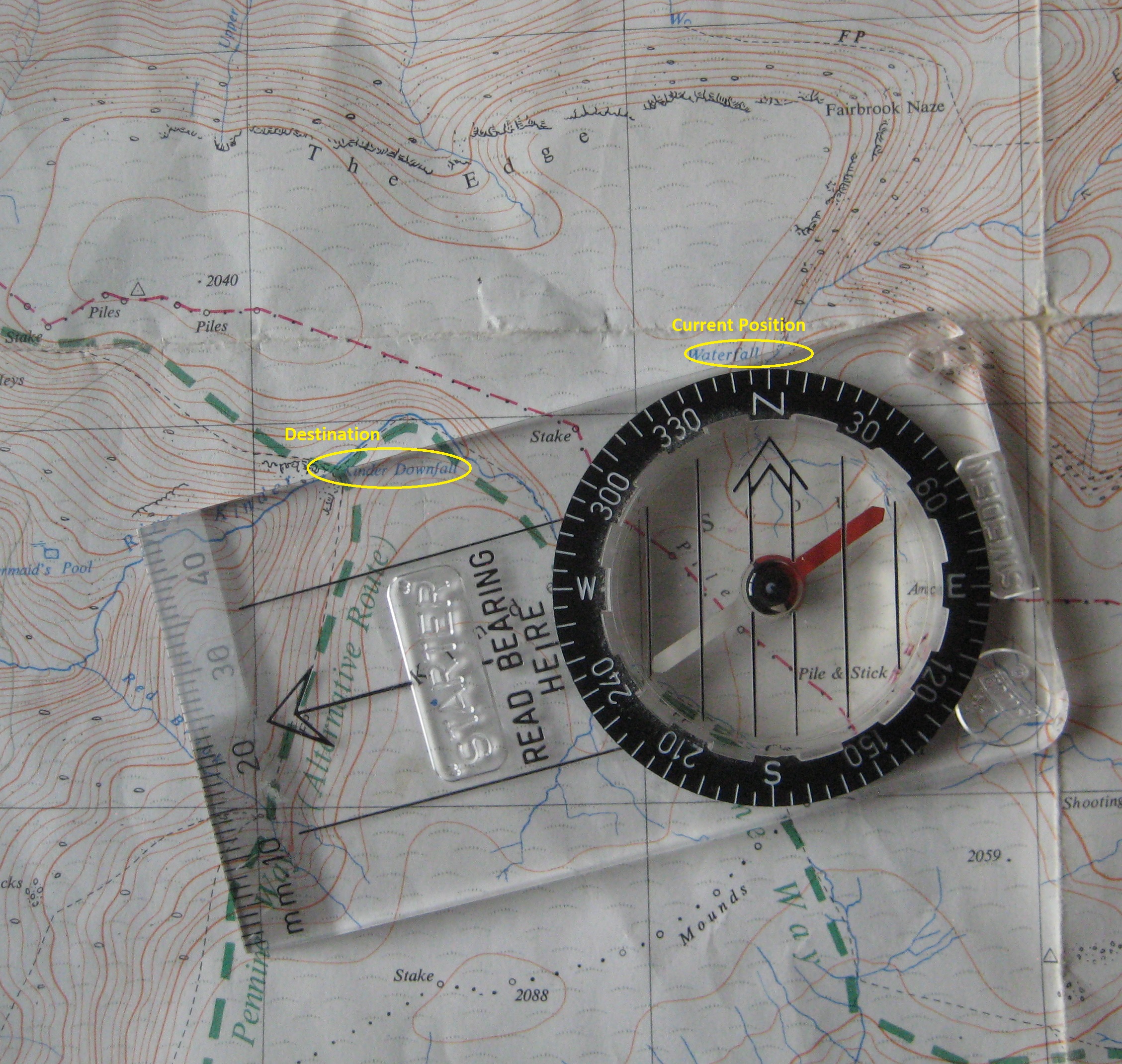
We also liked to cross the Derbyshire moorland plateau of Kinder Scout, from Fair Brook to Kinder Downfall. I wrote about it here. It is not far across, but the maze of deep, watery, peat ridges and trenches known as hags and groughs, twisting and turning in all directions, make it impossible to keep to a straight line. All distant features are below the horizon, so there is nothing you might aim towards. Unless you check your compass every few yards you go hopelessly off-course. 

Navigating With The Compass

From the top of Fair Brook to Kinder Downfall you follow a bearing of about 255 degrees, but you do not really need to know about bearings. All you have to do is set the compass using the map, and then follow it. Well, that is how I do it. 

The needle of the compass points red to the North. It swivels inside a black dial, which can be manually rotated on a transparent base plate. The base plate has a large arrow pointing away from the needle. 

You place the compass on the map with the large arrow pointing roughly in the direction you want to go, and then slide it so that one of the long edges of the base plate passes through both your current position and your target destination, e.g. from the top of Fair Brook to Kinder Downfall as circled in yellow in the photograph. You then rotate the dial so that North on the dial matches the grid lines on the map. There are lines inside the dial to help with this. It does not matter which way the map or the magnetic needle are pointing at this stage. 

Setting the compass: Fair Brook to Kinder Downfall

You can then put the map away for a while. Stand up and hold the base plate level with the large arrow pointing ahead of you. Slowly turn round until the red needle lines up with North on the dial, and walk straight ahead. It helps to choose a distant feature to aim towards, if one can be seen. 

There is a lot more to it, but I usually find this sufficient. You could adjust for the difference between Magnetic North and Grid North, but over short distances it probably does not matter much, so I am not going into that. It makes only about 2 degrees difference at present, although in past decades it has been as much as 10. It slowly changes. It is also worth mentioning that map grids do not always point to True North, but, again, it does not really matter. I could explain these different kinds of North, but do you really want to know? 

The 24-page leaflet explains all this in greater detail. I have archived a PDF copy here, in case you are nerdy enough to be interested. 

As mentioned at the start, this was my first compass. I later bought a new, supposedly more accurate mirror compass, but never got the hang of it. I simply fold out the mirror and use it in the same way as the old one. I believe that for greater accuracy you can read the needle through the mirror, and look at objects through the hole and the notch. I am told that you can even measure heights, if so inclined. But I would rather enjoy the countryside than study for qualifications in surveying. At least the new compass fits neatly into your trouser pocket without any sharp corners to castrate you when you sit down. And the mirror allows you to check your face is still perfect after a long day out in the wind and rain. 

Monday, 1 July 2024

Road To The Isles

New Month Old Post: first posted 2nd June, 2016
Sure by Tummel and Loch Rannoch and Lochaber I will go
As step I wi’ my cromack to the Isles.
Rannoch Moor fires the imagination with mystery and romance: the myths and legends; the forgotten history; the departed people; the abandoned ruins; the strange Gaelic names.

Said to be one of the last remaining wildernesses in Europe, it is a bleak stretch of blanket bog, lochans and rocky outcrops to the West of Loch Rannoch in Scotland. The West Highland Railway crosses it on the way to Fort William and Mallaig, over peaty terrain so wet that the Victorian engineers had to float the track on a mattress of brushwood, earth and ashes to stop it sinking into the bog.

Rannoch Viaduct 1975

Other than by train, the only way to Rannoch Station is by thirty miles of narrow B road meandering along the northern shore of Loch Rannoch from Pitlochry or Aberfeldy. Neville, Kev, and I, had driven there the previous Easter to sit cheerfully swigging our pints outside the Moor of Rannoch Hotel in the warm April sunshine. We watched a goods train rumble slowly north across the Rannoch Viaduct.

But it was the enigmatic wording of the signpost that caught our attention:

Road to the Isles signpost at Rannoch

PUBLIC FOOTPATH TO
FORT WILLIAM BY CORROUR
(THE ROAD TO THE ISLES)

What a walk that must be!

The following year, Easter was a full two weeks earlier and the seasons over two weeks later. A letter from Major J. D. Rennie of the Moor of Rannoch Hotel, Rannoch Station, Perthshire, replying to our enquiry, said that, yes, we could leave our car at the hotel for a few days provided we left the keys so they could move it if necessary. However, he still seemed surprised when we turned up in the snow. We camped that night beside the nearby lochan. By morning, the pan of water left outside had frozen solid. At least it was too cold and early in the year for the midges.

It would not be beyond endurance to walk the thirty miles from Rannoch to Fort William in a day, but it seemed ideal for a first attempt at backpacking. We loaded our aluminium framed rucksacks, left the car keys with the Major, and set off northwards beside the railway track. And apart from the railway track, there was little else to see for the first ten miles but vast, uninhabited empty moorland. Being Easter Sunday, there weren’t even any passing trains to disturb the isolation. Remote, beautiful, desolate! We saw no one else all day.

The land gradually rises to a summit beyond Corrour, the next station on the line. It was shrouded in mist. The station, since made popular by the film Trainspotting, is now busy with walkers and mountain bikers, and Corrour Station House is a popular restaurant and guest house, but in 1975 there was very little there. We passed without much pause heading for our first overnight camp at Loch Treig. It could not come soon enough. My feet were a mess. Idiotic to attempt such a walk in new boots.


The next morning, bright sunshine reflecting from the loch and mountains bathed everything in a brilliant blue light. We set off west, away from the railway, along the southern shore of Loch Treig. The loch is dammed at the northern end, and two lost communities, Kinlochtreig and Creaguaineach, lie submerged beneath the waters close to where we were. As if drawn to them, my blistered feet refused to go far that day and we camped again about a mile and a half beyond the loch, near the Staoineag ruin beside the Abhainn Rath river we were following. There was wood to light a fire and, again, no one around to complain.

 Loch Treig

We covered about eight miles on day three, struggling with our heavy rucksacks across difficult ground. Continuing west, the river becomes angrier and whiter, the wide banks giving way to a steep-sided valley sparsely lined with silver birch. It then becomes still again, with banks of stony mudflats, and the country opens up into wide, browny heath and moorland. But as you approach the once fine house of Luibeilt, now a lonely ruin, you have to ford the river.

Near Luibeilt

We knew the technique. Trouser legs up, socks off, boots back on, wade across with caution, and most importantly, do not lose your footing. The river was not particularly high and should have been trouble free, but it wasn’t. At least I was not the one to slip and fall in, losing the capacity either to give or refuse consent to be photographed ignominiously paddling out.

While drying out, two countryside rangers waded across, the only others we saw on the whole walk. As you would expect, they made it look easy. We chatted with them for the next few miles. They asked whether we had been staying at Luibeilt. It was listed by something called The Mountain Bothies Association as a place of overnight refuge. It sounded good for the future and I joined fairly soon afterwards. 

The rangers sped ahead and disappeared into the distance as we approached the east-west watershed where the water flowing east towards Loch Treig along the Abhainn Rath becomes the water flowing west to Fort William down the Water of Nevis. Several valleys converge here and it was not immediately obvious which one to take, but a bit of map and compass work put us safely in the right direction. No G.P.S. in those days. The slight uncertainty makes for much more fun.

Mountains above Glen Nevis

We camped again surrounded by the mountains of the Nevis valley: Aonach Beag, An Garbhanach, and Binnein Beag where deer came down the slopes in the night and made their way back up the next morning, avoiding the worst of the snow that sprinkled the tent.

Higher Glen Nevis

We were soon up and on our way again, descending through the steep gorge of Glen Nevis to the end of the road at the base of Ben Nevis, where the misspelt signpost indicated whence we came.*

Public footpath
to Carrour 15
and Rannoch 25

Public footpath sign to Corrour and Rannoch below Ben Nevis

But that was not the end. We still had to face another five gruelling miles along the narrow road to the Glen Nevis camp site.

We allowed ourselves the next day off, and early the day after that packed up and hiked into Fort William for the train back to the car. It was a little further to walk than now. The original Fort William station alongside Loch Linnhe, with its turreted entrance on the main street, was still in use. It closed and moved east to the present site two months later.

Route: Rannoch to Fort William

Rail Ticket: Fort William to Corrour 1988
I did that walk twice again with different friends, once in 1978 and again in 1988, both times by taking the train to Corrour from the new station at Fort William, thus omitting the wearisome Rannoch to Corrour stretch. Sensibly, we also left one of our cars at the end of the Nevis road making it just a fifteen-mile walk – a good day out. On both occasions we were the only ones to leave the train at the deserted Corrour halt, to the incomprehension of the other passengers who looked down (both physically and metaphorically) from the carriage windows with bemusement at our cagoules, walking boots and daysacks. 

I doubt it would be such a solitary walk now that most days the train deposits scores of walkers and mountain bikers at Corrour to follow numerous routes around the moor. The station is used by over twelve thousand passengers per year, an average of over thirty a day, but probably many times more in summer and fewer in winter. “Like a Wallace Arnold bus trip,” my dad would have said. It is a privilege to be able to say I was there in quieter times, nearly fifty years ago, but it would be wonderful to go again.

Take it away, Andy:

https://youtu.be/KtsAfk6h8mI


Notes

* The same sign and post are still at Glen Nevis (or were until relatively recently). The sign is considerably weathered, but the spelling of Corrour has been corrected and further signs to Spean Bridge, Corrour Station and Kinlochleven affixed in both Scots Gaelic and English. 

On one of the later occasions there were signs of construction taking place at Luibeilt, but I see from more recent accounts that it is now a ruin without roof, woodwork or some walls.

I would not be so confident drinking water from mountain streams now.