Google Analytics

Monday 22 April 2024

Warp Land

The flatland where the River Humber branches into tributaries was once an expanse of permanent marsh. It dried out gradually over the centuries with the construction of river banks and drainage ditches, making agriculture possible. Some areas were improved by a process known as warping.

In warping, river waters are diverted into the fields to deposit layers of fine, fertile silt. It is carried out by building low embankments around the fields and filling them through a breach or sluice in the river bank. The water flows into the fields at high tide, and after being allowed to settle, is drained back as the tide goes out, leaving silt behind. When carried out regularly over two or three years, three feet of silt might be laid down. 

I remember my uncle, the farmer (see Aunty Bina’s Farm), explaining why he preferred certain fields for crops, and others for his “be-asts”. Potatoes, sugar beet, and wheat grew best on warp land, whereas the cattle grazed on pasture. 

I may be mistaken, but looking now on Streetview, I fancy that the line of the low bank around the field followed the line of the lane. The fields were for crops, while the cows grazed behind the house. 

But thinking about it now, it puzzled me. The buildings in the far distance are on the other side of a railway line, and there is a canal beyond that, with the river at the other side of the canal. How could the river water have been diverted into the fields? 

Perhaps the water came from a different river. The River Aire is around two miles to the North behind the camera, and the River Ouse about three miles to the East, but I think these would have been too far, and several main roads, the villages of Rawcliffe and Airmyn, and the town of Goole were in the way. My guess is that the warp water must have come from the river beyond the railway, canal, and buildings - the Dutch River (or River Don). 

Wikipedia provides an answer: “The first reliable report of warping seems to come in the 1730s from Rawcliffe, which is near the confluences of the Ouse with the Aire and the Don, where a small farmer called Barker used the technique.” Neither the railway nor the canal would have been there then. The Knottingley and Goole Canal was opened in 1826, and the Wakefield, Pontefract and Goole section of the Lancashire and Yorkshire Railway in 1846. The warping must have been done before these dates. Some of the brick outhouses at the farm could easily have dated from that time, and knowledge of the warping would have been passed down by word of mouth. 

The railway, canal, and Dutch River can be seen running parallel in the lower left quarter of this 1962 map (pre-motorway). The oddly straight Dutch River is clearly another man-made feature. It was constructed in the 1630s by Dutch engineers, who diverted the River Don to drain the moors of Hatfield Chase, hence the name “The Dutch River”. The River Don originally flowed further East into the River Trent. Warping of my uncle’s land must have used water from the diverted river Don. 

More extensive warping schemes were carried out in the Nineteenth Century along the original course of the Don, as far East as Adlingfleet on the Trent, and as far South as Crowle. One large area is served by the enormous Swinefleet Warping Drain (centre bottom of map) which runs for 5.6 miles (9 km) and has a permanent sluice into the River Ouse. The drain and much of the network of drainage ditches are deep and wide. Some are stocked with fish for anglers, and all provide habitats for frogs, sticklebacks, water voles, and other wildlife. It is astonishing to think it was all dug out by hand. But, we do not only alter our landscape. Families with Dutch names still live in the area, and the local name for drainage ditches is dykes. 

Swinefleet Warping Drain

Swinefleet Sluice where the warping drain enters the Ouse

Two areas of unreclaimed land remain just to the South: Thorne and Hatfield Moors, which together form the largest expanse of lowland peat bog in the country. Even the intrepid Yorkshire Pudding’s Geograph project has not much ventured there.  

One last piece of trivia. In the film “The Dam Busters” (1955), the aeroplanes are shown flying along a Dutch canal. It was actually filmed flying East along the Dutch River. The Goole shipyard cranes can be seen as the planes approach the River Ouse and then bank left over the town. Please don’t tell the East Riding Council. It will give them ideas about what to do with the place. 

Dave Northsider is now trying to work out how he can divert river water into his polytunnel. 

Tuesday 16 April 2024

Wainwright’s Mardale Green

Rosemary (Share My Garden) wrote about her visit to Tyneham, a village in Dorset abandoned in the Second World War because it was in an area needed for military training. The residents never returned.

She also remembered, as a child, picking gooseberries in the garden of a house in a village abandoned to the rising waters of a new reservoir.

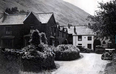
Mardale Green

It reminded me of a passage in ‘Fellwalking With Wainwright’, which has haunted me since I bought the book in 1985. I think of it often. Oh to be able to write like Wainwright. 

I will never go to Mardale Head now without thinking of a summer’s day more than forty years ago when I walked over Gatescarth Pass and saw the valley of Mardale for the first time. It was a lovely vista. The floor of the dale was a fresh green strath shadowed by fine trees and deeply inurned between shaggy heights; beyond, receding in the distance, was Haweswater, then a natural lake. It was a peaceful scene, the seclusion of the valley being emphasised by its surround of rough mountains. Mardale was a bright jewel in the dark crown .... I remember that day so well. Many early memories have faded, but not that one. Down in the valley, I went along the lane to the Dun Bull between walls splashed with lichens and draped with ivy. There was no welcome for me at the inn, which for centuries had been a meeting place for farmers and shepherds and the scene of many festive gatherings. It was empty, unoccupied. Around the corner was the small church amongst fine yews: it was a ghostly shell, the interior having been dismantled and the bodies in the graveyard exhumed and reburied elsewhere. The nearby vicarage and a few cottages were deserted and abandoned. This was the hamlet of Mardale Green, delightfully situated in the lee of a wooded hill, but now under sentence of death. Birds trittered in the trees and my footsteps echoed as I walked along the lane but there was no other sound, no sign of life. Even the sheep had gone. There were wild roses in fragrant hedgerows, foxgloves and harebells and wood anemones and primroses in the fields and under the trees, all cheerfully enjoying the warmth and sunshine; but there would be no other summers for them: they were doomed ... Manchester Corporation had taken over the valley and built a great dam. The lake would be submerged beneath a new water level a hundred feet higher. Already the impounded waters were creeping up the valley. Soon the hamlet of Mardale Green would be drowned: the church, the inn, the cottages, and the flowers, would all disappear, sunk without trace, and its history and traditions be forgotten. The flood was coming and it would fill the valley. Nature’s plan for Mardale would be over-rules. Manchester had other plans, to transform Mardale into a great Haweswater Reservoir. And no doubt be very proud of their achievement ... I climbed out of the valley to Kidsty Pike. Looking back at Mardale Green from a distance, its buildings no longer seeming forlorn but cosily encompassed by trees and its silent pastures dappled by sunlight, I thought I had never seen a more beautiful picture. Nor a sadder one.